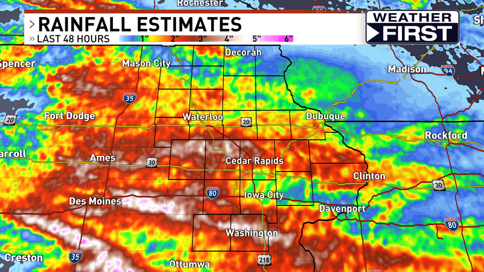
Heavy Rainfall and Flooding Impact Eastern Iowa
A series of showers and storms that occurred between Saturday and Sunday brought significant rainfall to eastern Iowa. The weather conditions were particularly intense on Saturday morning, with some storms generating wind speeds of up to 60 mph and producing hail the size of quarters. These severe weather events led to widespread concerns about potential damage and safety issues.
In addition to the strong winds and hail, multiple flash flood warnings were issued as the region experienced rapid rainfall accumulation. The ground had already been saturated from previous rainfall, making it more susceptible to flooding. As a result, roads, rivers, creeks, and streams saw rising water levels, leading to localized flooding in several areas.
Some rivers were already at high levels and approaching flood stage due to the heavy rain from the previous week. This means that even a small amount of additional rainfall could push them over the edge, increasing the risk of further flooding.
While all parts of eastern Iowa received a substantial amount of rain, certain areas experienced significantly higher totals. According to a map showing the distribution of rainfall, regions shaded in brown, white, and pink indicate the highest amounts of precipitation. These areas include parts of Tama, Benton, Linn, Iowa, Keokuk, and Washington counties. Residents in these locations may have faced more severe impacts from the storm activity.
After the initial round of storms on Saturday, a second wave of showers and thunderstorms moved through on Sunday morning. However, by the afternoon, the weather activity began to subside, offering a temporary reprieve for many residents.
Looking ahead, the forecast suggests relatively quiet weather for the beginning of the week. There is a chance for a few isolated storms between Monday and Tuesday, but these are expected to be light and short-lived. However, as the week progresses, the likelihood of rain and thunderstorms is expected to increase. This could bring more heavy rainfall and stronger storms, which may lead to additional flooding concerns given the already highly saturated ground.
It is important for residents to stay informed about the weather conditions and monitor updates from local meteorological services. Continued vigilance is necessary, especially in areas that have already experienced flooding or are at risk of future flooding. Having multiple ways to receive weather warnings, such as through mobile apps, radio, or television, can help ensure that individuals are prepared for any changes in the weather.
As the week unfolds, it is recommended to check in regularly with local weather experts for the latest forecasts and advisories. Staying updated can make a significant difference in ensuring safety and minimizing the impact of potential severe weather events.


