
A cold front brought temperatures ‘colder than Antarctica’ to Australia’s southeast over the weekend, but while it has passed, more cool conditions are on the way.
Australia is set to shiver from Monday with a massive low bringing strong winds, making conditions colder than recorded temperatures.
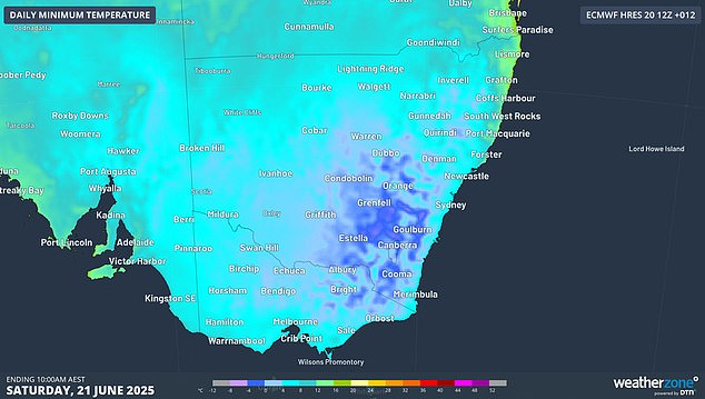
Temperatures across
NSW
and the ACT plummeted on Saturday morning with several towns recording their lowest temperatures in eight years.
Davis Station, one of Australia’s research stations in Antarctica, reached -8.4C while Goulburn, 195km southwest of
Sydney
, recorded a bone-chilling -10C.
‘This was Goulburn’s coldest morning in eight years and its coldest June morning in a quarter of a century,’ Weatherzone meteorologist Corine Brown said.
Canberra came close to Arctic levels with -7.6C recorded shortly before 6am, also an eight-year record and the capital’s coldest June morning in 39 years.
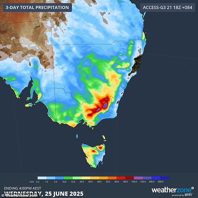
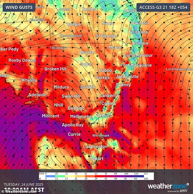
While that front shifted further east on Sunday, a ‘really powerful low’ moving across the Great Australian Bight is set to continue the icy trend.
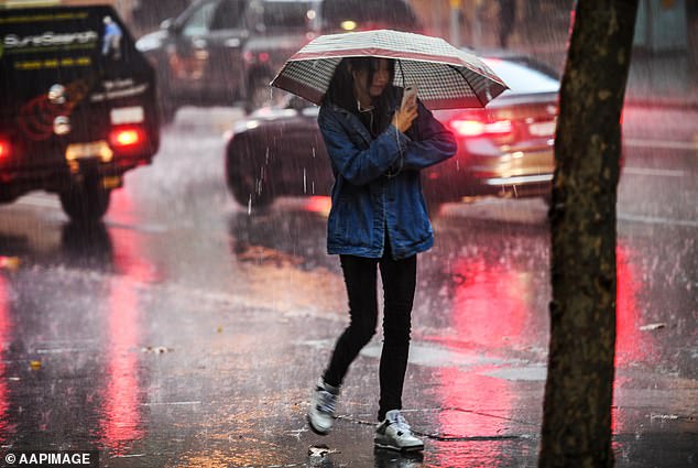
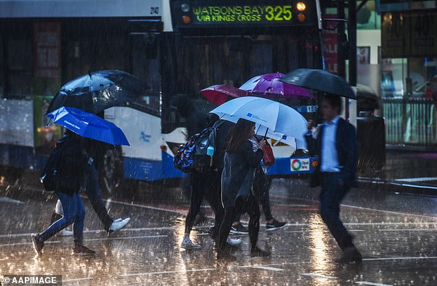
That system is set to bring damaging wind gusts and rain to large areas of SA, NSW and Victoria.
WA’s southwest saw the beginning of the low’s effects on Monday morning, with rain spreading from Margaret River to Esperance.
On the system’s eastern side, wind gusts began picking up on SA’s coastline on Sunday night and are expected to strengthen as the low tracks east.
‘Those winds are then expected to increase over southeastern states in the coming days as the low continues to track east, crossing Tasmania late on Tuesday,’ Ms Brown said.
‘Damaging wind gusts are expected for parts of SA, Victoria, NSW, the ACT and Tasmania, including capital cities, mainly on Tuesday and Wednesday.’
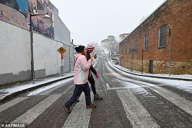
The front will be unfortunate news for snow sport lovers, with a severe weather warning issued by the Bureau of Meteorology for alpine regions across NSW and Victoria.
‘Minimum temperatures will warm most significantly from Tuesday as a strong cold front brings increasing cloud cover to NSW and the ACT,’ Ms Brown said.
‘However, maximum temperatures on Tuesday and Wednesday could be extremely cold, with the potential for blizzard conditions over the Australian Alps, and gusty, damaging winds over VIC, NSW and the ACT.
‘So keep an eye on your local forecast and make sure to rug up in the days ahead.’
As the low moves into NSW, it is expected to bring widespread rain throughout its central regions.
That rain is set to fall as snow down to 500m above sea level on Wednesday.
The cold conditions are also forecast to cause frost with warnings in place up to the state’s northern tablelands.
Sydney
Tuesday
: Cloudy. The chance of fog in the outer west in the early morning. High chance of showers, most likely in the morning and afternoon. Winds northerly 15 to 25 km/h turning northwesterly 15 to 20 km/h in the afternoon. Min 13. Max 21.
Wednesday
: Mostly sunny morning. Slight chance of a shower, most likely in the afternoon and evening. Winds northwesterly 15 to 25 km/h increasing to 25 to 40 km/h during the morning then turning westerly during the day. Min 11. Max 17.
Thursday
: Mostly sunny. Slight chance of a shower along the coastal fringe, most likely in the evening. Near zero chance of rain elsewhere. Winds west to southwesterly 15 to 25 km/h tending south to southwesterly during the day then becoming light during the evening. Min 8. Max 16.
Melbourne
Tuesday
: Partly cloudy. High chance of showers, with possible small hail in the northwest suburbs at night. Winds northerly 25 to 40 km/h turning northwesterly in the middle of the day. Min 12. Max 16.
Wednesday
: Cloudy. Very high chance of showers, most likely in the morning and afternoon. Possible small hail. Winds northwesterly 20 to 30 km/h turning southwesterly 25 to 35 km/h during the day then decreasing to 15 to 25 km/h during the evening. Min 7. Max 11.
Thursday
: Cloudy. Medium chance of showers, most likely in the morning. Winds west to southwesterly 15 to 20 km/h becoming light during the afternoon. Min 7. Max 13.
Brisbane
Tuesday
: Partly cloudy. High chance of showers, most likely in the evening. Light winds becoming northerly 15 to 20 km/h in the early afternoon then becoming light in the late afternoon. Min 15. Max 25.
Wednesday
: Medium chance of showers in the morning. Sunny day. Winds west to northwesterly and light becoming westerly 15 to 20 km/h during the morning then increasing to 25 to 40 km/h during the day. Min 16. Max 24.
Thursday
: Sunny. Winds westerly 20 to 30 km/h becoming light during the morning. Min 11. Max 21.
Perth
Tuesday
: Partly cloudy. The chance of morning fog. Light winds. Min 7. Max 19.
Wednesday
: Mostly sunny. Light winds. Min 6. Max 19.
Thursday
: Mostly sunny. Slight chance of a shower. Light winds becoming northerly 15 to 20 km/h during the day then becoming light during the afternoon. Min 6. Max 20.
Adelaide
Tuesday
: Cloudy. Very high chance of showers. The chance of a thunderstorm. Possible small hail in the evening. Winds northwesterly 30 to 45 km/h tending westerly 25 to 40 km/h in the middle of the day. Min 8. Max 14.
Wednesday
: Cloudy. Very high chance of showers, most likely in the morning. Winds west to southwesterly 25 to 40 km/h tending south to southwesterly 25 to 35 km/h during the day then becoming light during the evening. Min 9. Max 15.
Thursday
: Cloudy. Slight chance of a shower. Light winds. Min 7. Max 15.
Hobart
Tuesday
: Partly cloudy. Medium chance of showers, most likely in the evening. Winds northerly 20 to 30 km/h turning northwesterly 20 to 25 km/h during the afternoon and evening. Min 10. Max 16.
Wednesday
: Cloudy. High chance of showers, most likely in the morning. Possible small hail. Winds west to northwesterly 15 to 25 km/h tending west to southwesterly 20 to 30 km/h during the morning. Min 6. Max 11.
Thursday
: Cloudy. Slight chance of a shower. Winds westerly 15 to 25 km/h becoming light during the evening. Min 4. Max 14.
Canberra
Tuesday
: Cloudy. Very high chance of rain, most likely in the morning, easing to showers in the afternoon. Winds northerly 15 to 25 km/h tending northwesterly 20 to 30 km/h in the morning. Min 5. Max 14.
Wednesday
: Cloudy. Very high chance of showers, most likely in the morning and afternoon. Winds northwesterly 25 to 35 km/h tending westerly during the afternoon then decreasing to 15 to 25 km/h during the evening. Min 1. Max 8.
Thursday
: Mostly sunny. Areas of morning frost. Winds westerly 15 to 20 km/h becoming light during the morning. Min -3. Max 11.
Darwin
Tuesday
: Partly cloudy. Light winds becoming east to southeasterly 15 to 20 km/h in the middle of the day then becoming light in the early afternoon. Min 21. Max 32.
Wednesday
: Mostly sunny. Light winds becoming east to southeasterly 20 to 30 km/h during the morning then becoming light during the evening. Min 23. Max 32.
Thursday
: Partly cloudy. Light winds becoming southeasterly 20 to 30 km/h during the morning then becoming light during the evening. Min 22. Max 31.
Read more


