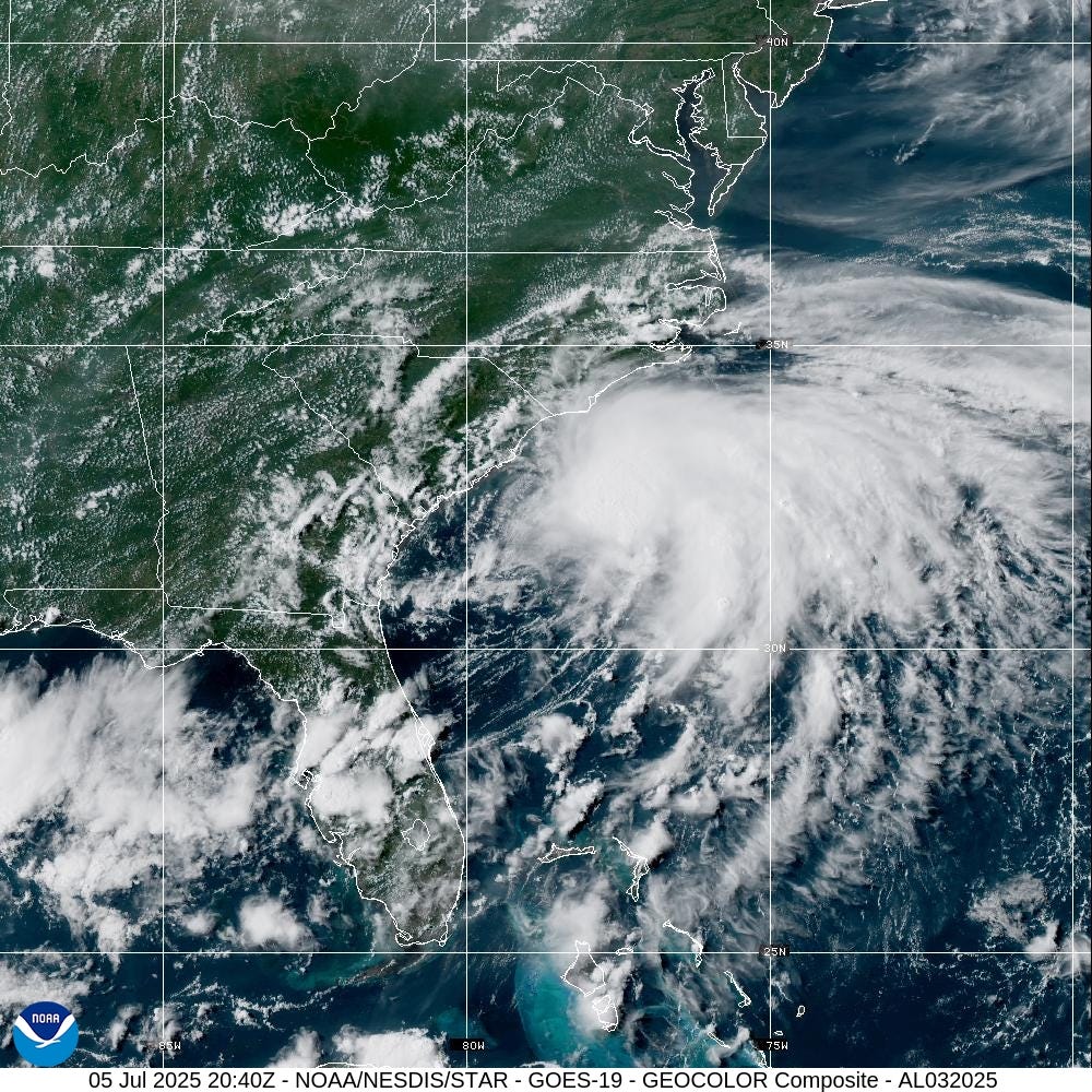
Tropical Storm Chantal Intensifies and Heads Toward the Carolinas
Tropical Depression 3 has evolved into Tropical Storm Chantal, according to the National Hurricane Center. As of Saturday, July 5, at 5 p.m., the storm was located approximately 95 miles southeast of Charleston, South Carolina, with maximum sustained winds of 45 mph and higher gusts.
The National Hurricane Center anticipates that Chantal’s peak sustained winds could reach up to 50 mph before it makes landfall. However, most of the stronger winds are expected to remain over the Atlantic Ocean, which is a positive development for the coastal areas of the Carolinas.
Chantal has increased its speed and is currently moving north at 7 mph. Forecasters predict that the storm will shift to a north-northwest direction this evening, with the center expected to cross the coast of South Carolina overnight or early Sunday. Tropical storm conditions are anticipated to begin in parts of the coastal Carolinas this evening and continue through Sunday morning.
A tropical storm warning is in effect from South Santee River, South Carolina, to Surf City, North Carolina. Additionally, a tropical storm watch has been issued for Edisto Beach to South Santee River, South Carolina. Conditions within these areas are expected to worsen over time.
Rainfall and Flooding Concerns
Tropical Storm Chantal is expected to bring heavy rainfall across portions of the coastal plain in the Carolinas through Monday. Storm total rainfall is projected to range between 2 to 4 inches, with some local areas receiving up to 6 inches. This significant amount of precipitation increases the risk of flash flooding, particularly in urban areas.
Isolated tornadoes are also possible tonight and on Sunday across parts of eastern South Carolina and eastern North Carolina. Residents in these regions should remain vigilant and monitor weather updates.
Coastal Impacts and Weather Alerts
Chantal is expected to bring showers and thunderstorms along Florida’s east coast, as well as rough surf and dangerous rip currents. The National Weather Service warns that seas and surf will build from the Florida Atlantic coast to the North Carolina Outer Banks during the extended Independence Day weekend.
At 5:00 p.m., the center of Tropical Storm Chantal was located near latitude 31.9 North, longitude 78.7 West. It is moving toward the north at 7 mph, with a forecasted shift to a north-northwest direction later this evening. By Sunday night, the storm is expected to turn northeast.
Maximum sustained winds are currently near 45 mph, with some slight strengthening expected before landfall. After making landfall, rapid weakening is anticipated.
Watches and Warnings
A Tropical Storm Warning is in effect for South Santee River, SC to Surf City, NC. A Tropical Storm Watch is active for Edisto Beach to South Santee River, SC. A warning indicates that tropical storm conditions are expected within the affected area, while a watch means such conditions are possible.
Residents along the southeast coast of the United States should closely monitor the storm’s progress. For specific information about your area, including inland watches and warnings, check updates from your local National Weather Service office.
Key Messages and Hazards
Tropical storm conditions are expected in the warning area starting this evening and continuing through Sunday morning. Heavy rainfall across the Carolinas will lead to flash flooding concerns through Monday, especially in urban areas.
Chantal is also expected to bring life-threatening surf and rip currents along the coast from northeastern Florida to the Mid-Atlantic states. Beachgoers should follow the guidance of lifeguards and local officials.
Spaghetti Models and Forecasting
Spaghetti models are used to illustrate various forecast tools and models. The National Hurricane Center relies on the top four or five highest-performing models to make its forecasts. These models help provide accurate predictions about the storm’s path and intensity.
Storm Tracking and Updates
The National Hurricane Center has introduced a new rip current risk map for the 2025 hurricane season. This map will be available for the current day, the next day, and as a composite showing the highest risk over both days for areas along the East and Gulf coasts of the United States, Puerto Rico, the U.S. Virgin Islands, and the coast of southern California.
Understanding the Hurricane Season
The Atlantic hurricane season runs from June 1 through November 30. Ninety-seven percent of tropical cyclone activity occurs during this period, according to NOAA. The peak of the season typically occurs around September 10, with the most activity between mid-August and mid-October.
Stay Informed and Prepared
Residents should stay updated on the latest weather alerts by signing up for text notifications. Interactive maps and real-time updates can help track the storm’s movement and potential impacts.
For more information on tropical storms and hurricanes, visit the National Hurricane Center’s website. Keep an eye on local news and weather services for ongoing coverage and updates.


